NORTH COAST, Calif. – The driver of a vehicle involved in a Friday double-fatal crash on Highway 20 in Mendocino County has been arrested.
Timothy Beltram, 62, of Fort Bragg was arrested on suspicion of driving a motor vehicle while under the influence of a drug resulting in death or injury following the solo-vehicle wreck, which occurred shortly after 8:30 p.m. Friday, according to the California Highway Patrol’s Ukiah Area office.
Beltram’s two passengers died in the wreck. The names of the two women – one age 51 of Fort Bragg, the second age 50 of Sacramento – were not released by the CHP on Sunday.
The CHP said Beltram was driving a blue 2002 Ford Focus westbound on Highway 20 west of mile marker 22.34, located between Fort Bragg and Willits, at approximately 30 to 40 miles per hour during rainy conditions.
According to the report, Beltram turned the Ford to the right and drove off the highway’s north embankment.
The Ford overturned multiple times, throwing one of the passengers from the vehicle. She died at the scene, the CHP said.
The second passenger died of her injuries at Santa Rosa Memorial Hospital on Saturday, according to the CHP report.
Beltram suffered major injuries, including broken right ribs, in the crash, the CHP said.
The CHP said Beltram and both of his passengers were wearing their seat belts at the time of the crash.
The crash remains under investigation, the CHP said.
Mendocino County Jail records show that Beltram was booked on Saturday morning, with bail set at $200,000.
Email Elizabeth Larson at This email address is being protected from spambots. You need JavaScript enabled to view it.. Follow her on Twitter, @ERLarson, or Lake County News, @LakeCoNews.
In turn of the century America, going out to the movies was an experience wildly different from today.
To begin with, if you wanted to see a motion picture, you were more likely to find it in front of stores on main street, projected onto a screen by a travelling exhibitor or at a carnival as a part of a vaudeville act.
“Movies” as we understand them did not exist. Instead, motion pictures of under a minute featured scenes of everyday life and usually only consisted of a single scene.
Rarely did these films go beyond two minutes. They were silent, choppy in appearance, sometimes blurry and difficult to follow and they fast became a sensation.
At a whopping 12 minutes long (!), the short 1903 film “The Great Train Robbery” fundamentally changed the experience of watching a motion picture.
When it first debuted at Huber’s Museum in New York City on Dec. 1, the lucky audience present was witness to the first narrative film in history.
Rather than viewing a motion picture for the sheer novelty of seeing simulacra of everyday life, people could now go to a theater to watch a story unfold – to be entertained not just by the magic of the film equipment, but by the artistry of the film director and actors.
The person who dreamed up such a groundbreaking film was Edwin S. Porter, the son of a furniture merchant from Connellsville, Pennsylvania.
When he was 14 years old, Porter dropped out of school and began a spate of odd jobs that would inexorably lead him to his career in the film industry.
He worked for a time as a theater cashier and stagehand and eventually as a machinist specializing in the installation of electrical equipment. In the latter job, Porter contributed to Bradley A. Fiske's development of the electric rangefinder.
In 1893, Porter joined the Navy and served three years. When he returned home to Pennsylvania, he found that his friends had purchased the sole rights to screen films with Thomas Edison's Vitascope projector from promoters and distributors Raff & Gammon.
After working for his friends as a projectionist in Los Angeles and Indianapolis. In 1900, he was asked to come work for the Edison Co. to help them tweak filmmaking equipment and develop new filming techniques.
As Edison’s director-cameraman, Porter began directing and filming more advanced motion pictures, including ones featuring multiple scenes and others with special effects.
In 1903, he developed and filmed “The Great Train Robbery.” The movie opened with a bang – literally, as the film’s outlaw star Justus D. Barnes aimed his gun directly at audiences and opened fire.
The action continued unabated for 12 minutes, as the story of an outlaw band’s failed attempt at robbing a train unfolded scene by scene.
This film featured a number of firsts. For the first time in film history, scenes were shot “on location,” which in this film’s case was on train tracks somewhere in New Jersey, in addition to the studios.
It was the first to use modern film techniques, such as multiple camera positions, filming out of sequence and later editing the scenes into their proper order. And for western fans out there, it was one of the very first western films ever produced.
Audiences in New York City, where the film was initially released, raved about it. His film’s success allowed Porter more freedom within the Edison Co. to create his own one-reel films.
After leaving the Edison Co. in 1909, Porter continued in the film industry on his own for two decades with success.
The crash of the stock market at the end of the 1920s, however, doomed Porter to spend the final years of his career taking any old job he could find as a machinist.
He died with little fanfare in a hotel in New York City in 1941. His films, however, live to this day in the thousands of subsequent movies that built upon his work.
Antone Pierucci is curator of history at the Riverside County Park and Open Space District and a freelance writer whose work has been featured in such magazines as Archaeology and Wild West as well as regional California newspapers.
Every morning for the past 16 years, solar physicist Säm Krucker sat down at his desk to check the latest data from NASA’s RHESSI. Had the solar observatory seen a flare overnight?
If there was a new flare, Krucker, RHESSI principal investigator at University of California, Berkeley, since 2013, would pore over the data, each recorded X-ray telling him something about the giant explosion on the Sun.
Now, many years after launching on Feb. 5, 2002, the RHESSI — short for Reuven Ramaty High Energy Solar Spectroscopic Imager — mission has ended; Krucker, and many other scientists, will no longer check the spacecraft’s data returns each day.
In anticipation of losing touch with the spacecraft’s aging receiver, mission operators sent the spacecraft commands to decommission on Aug. 16, 2018.
“It does impact everyday life that way,” Krucker said. Though it’s appropriate timing for RHESSI to stop operations now, he said, while the Sun nears solar minimum, the lull in its activity over an approximately 11-year cycle. “The next two to three years would have been quite boring.”
RHESSI’s job was to watch the Sun for solar flares, some of the most dramatic events on the Sun that can sometimes fling solar energy toward Earth.
During a flare, gas in the Sun’s atmosphere rapidly soars over 20 million degrees Fahrenheit, sending particles flying at near-light speeds. In turn, the particles emit high-energy emissions like X-rays and even higher gamma rays, which we can detect from far away.
These rays can’t, however, penetrate Earth’s atmosphere and be measured from the ground, so RHESSI observed them from space. In doing so, RHESSI aimed to understand how flares work, the physics underlying how the Sun generates such powerful bursts of energy.
Ask any scientist who worked on RHESSI what their favorite flare is, and they’ll easily rattle off a date, as if it’s a birthday or holiday they’ll always remember. Krucker said his favorite is either Jan. 20, 2005, or July 19, 2012.
Mission scientist Brian Dennis at NASA’s Goddard Space Flight Center in Greenbelt, Maryland, said April 21, 2002, RHESSI’s very first X-class flare – the strongest type. For them, these are special dates because RHESSI taught them something new that day.
“When I first looked at the Jan. 20 flare and saw where the high energy was coming from, that brought my understanding to the next level,” Krucker said. “One guy even has a most-hated flare. He had many arguments with colleagues over it, trying to explain it, which was not always pleasurable.”
Throughout the course of its mission, RHESSI saw more than 75,000 solar flares. These observations have helped scientists craft and refine a model of how solar eruptions form. Launching in early 2002, just after the Sun reached solar maximum in 2001, the spacecraft was poised to see many flares.
“High energies are always interesting in astronomy,” University of Minnesota solar scientist Lindsay Glesener said. “They’re the biggest explosions, the hottest plasma. But flares are going on at our Sun, which is right next to us and affects us in lots of ways. When I was a grad student, it took just one conversation with Robert Lin, the principal investigator from 2002 to 2012, to convince me flares are the most fascinating thing in the universe.”
To understand how solar flares erupt from the Sun, you have to know where their energy comes from. For this, RHESSI carried just one instrument, called an imaging spectrometer, capable of recording both X-rays and gamma rays. For scientists, these high-energy emissions are like fingerprints, showing them how each eruption unfolds: X-rays are associated with electron activity, while gamma rays come from protons and ions.
The instrument combined images of the Sun with its spectroscopy to show all the different energy levels in the flare. This allows scientists to map out where energy comes from during an explosion, and what’s producing that energy.
“Previous mission designs had two different instruments, but RHESSI was able to study this large energy range in X-rays and gamma rays, all with the same instrument,” said Albert Shih, RHESSI deputy mission scientist at Goddard. “It was an innovative design, and a lot of good science came of it.”
RHESSI’s observation of so many flares over the years, from one solar cycle to the next, broke new ground in solar physics and enabled a much deeper understanding of flares — where they accelerate particles, and just how much they can vary in scale, from tiny nanoflares to massive superflares, tens of thousands of times bigger and more explosive.
“RHESSI had several firsts,” Dennis said. “No one had ever imaged X-rays at this high an energy level before, or imaged gamma rays at all. RHESSI made great strides by making energy measurements with higher resolution than had previously been possible.”
Solar flares aren’t simple
With these unprecedented capabilities, RHESSI gave scientists entirely novel information, revealing just how complex flares can be.
Early RHESSI observations of a strong flare on April 15, 2002, showed X-rays coming from two different places at once: one high in the Sun’s atmosphere and another lower down. Researchers interpreted this to mean a huge punch of energy occurred between the two spots.
After tracking the energy in the two-sided explosion, they realized part of the explosion’s energy shot high into the Sun’s atmosphere and burst into a cloud of hot plasma to become a coronal mass ejection, while the other part bore down towards the surface, exploding into a flare.
These explosions – the most powerful in the solar system – came to be known as solar eruptive events, in which the Sun’s strongest flares and coronal mass ejections are linked, occurring at the same time.
RHESSI introduced solar researchers to entirely new questions on the nature of flares. During an intense October 2003 flare, scientists noticed X-rays and gamma rays coming from two different places. Although electrons and ions have different masses, scientists expected them to originate from the same spot in the flare.
Since each kind of emission reflects the presence of different kinds of particles, the unexpected disparity hinted at different mechanisms guiding the movements of each type of particle. Scientists still don’t fully understand this process.
“Thanks to RHESSI, we know much more about where particles are accelerated in flares,” Glesener said. “But how they get accelerated remains a big mystery. RHESSI told us where we need to look in order to finish answering these questions.”
The shape of our star
RHESSI’s long-term data sets also led to findings that have nothing to do with flares at all. One major result concerned the shape of the Sun itself. Since it constantly spins, scientists expect the Sun, like Earth, to be a slightly flattened sphere with a bulging waistline.
But pre-RHESSI measurements of the Sun determined it to be much flatter than theory dictated, raising questions of whether scientists had overlooked some crucial piece of information in their calculations.
RHESSI put their confusion to rest through the routine information it gathered to assess where its instrument was pointing.
To keep perfectly oriented, the spacecraft precisely recorded the position of the Sun’s horizon 16 times per second. With such an extensive collection of data, scientists were able to determine the best ever measurement of the Sun’s shape — and a close match to theoretical predictions.
Understanding Earth’s lightning storms
RHESSI’s watch of gamma rays throughout the sky made it a prime tool to measure what are called terrestrial gamma-ray flashes, bursts of gamma rays emitted from high in Earth’s atmosphere over lightning storms.
The first of these had been spotted before, but RHESSI invigorated an entire field of study when it showed they are more common and luminous than previously thought. Current numbers suggest there may be as many as 400 bursts daily from thunderstorms at different locations around the world.
The finding spurred new research, CubeSat observations and computer modeling.
More science to come
Throughout RHESSI’s lifetime, scientists made the most of the mission by integrating its observations with those from other missions such as NASA’s Solar Dynamics Observatory and STEREO, short for the Solar and Terrestrial Relations Observatory.
Different instruments focus on different aspects of the Sun, or different levels of energy. By combining various vantage points across NASA’s fleet of heliophysics spacecraft, researchers could piece together a holistic picture of the Sun’s complex behavior.
Scientists expect RHESSI will continue to shed light on flares for years to come, as they continue to parse its trove of data.
With RHESSI no longer in operation, solar researchers do not currently have a way to monitor high-energy flare emissions. But new missions under development carry the torch of RHESSI’s legacy.
“RHESSI established many young scientists, generating an entire class of high-energy solar physicists,” Krucker said. “If you look at who’s leading the next generation of X-ray telescopes now, they come from RHESSI science.”
Glesener and Shih both began their doctoral studies in solar physics with RHESSI data. Now, each is deeply involved with developing and testing advanced high-energy solar instruments for new missions — including the FOXSI sounding rocket and GRIPS high-altitude balloon.
“Throughout its 16 years, it was RHESSI answering questions, but asking new ones along the way, that has motivated future missions,” said Shih, who is also the GRIPS project scientist. “RHESSI set the groundwork and framed our expectations for missions that will look at the Sun in even more detail as we investigate entirely new mysteries.”
RHESSI first launched as HESSI in February 2002, but was renamed just months after launch, in April that year, in memory of Reuven Ramaty, a deceased NASA scientist who had long championed the mission. The nominal two-year mission was first extended in 2004 for two years, and then extended several times more until its end.
Currently, RHESSI is in a stable low-Earth orbit. But since it has no propulsion, atmospheric drag will continue to tug at its orbit until the satellite reenters Earth’s atmosphere, which is expected to occur as early as 2022. NASA will monitor the satellite’s deorbiting and reentry.
RHESSI belongs to a class of NASA spacecraft called Small Explorers, missions that cost under $120 million with highly focused research goals. Goddard manages the Explorers Program for NASA's Heliophysics Division within the Science Mission Directorate at NASA Headquarters in Washington.
The Explorers Program Office at Goddard provides management and technical oversight for RHESSI. RHESSI is a collaboration between Goddard, UC Berkeley, the Paul Scherrer Institute in Switzerland and General Dynamics in Arizona.
Lina Tran works for NASA’s Goddard Space Flight Center, Greenbelt, Md.
MIDDLETOWN, Calif. – Authorities said that two women died Saturday night in a head-on collision near Middletown.
The crash occurred on Highway 29 south of Grange Road at approximately 10:23 p.m. Saturday, according to a report from the California Highway Patrol’s Clear Lake Area office.
The CHP said two Clearlake women died in the wreck – one age 46, the other age 77 – but did not release their names Sunday pending the notification of next of kin.
The report said that the younger woman was driving a red 2011 Nissan Sentra southbound on Highway 29 south of Grange Road while the older woman was driving a blue 1999 Ford Ranger northbound.
The woman driving the Nissan crossed over the solid double yellow lines, traveling directly into the Ford’s path, which resulted in the head-on collision, according to the report.
Emergency personnel arriving on the scene found one of the women already had died, according to radio reports.
Firefighters then extricated the second woman, who the CHP said also died at the scene.
The report said the Nissan’s driver was wearing her seat belt while the Ford’s driver was not.
The CHP said the cause of the crash remains under investigation.
Email Elizabeth Larson at This email address is being protected from spambots. You need JavaScript enabled to view it.. Follow her on Twitter, @ERLarson, or Lake County News, @LakeCoNews.
LAKE COUNTY, Calif. – The annual Lake County Burn Ban for 2018 will be lifted as of 8 a.m. Monday, Nov. 26, the Lake County Air Quality Management District reported.
Burn permits are required for all outdoor burning in the Lake County Air Basin.
A smoke management plan is required for all burns over 20 acres in size, multi-day burns, standing vegetation burns, whole tree or vine removals over one acre, and other burns where significant smoke impacts may occur or sensitive receptors may be impacted.
A fee is required for all burn permits, payable at the time the permit is issued.
Burn permits (agricultural and residential) and smoke management plans are $27, while land development/lot clearing burn permits are $81.
Only clean dry vegetation that was grown on the property may be burned.
Residential burn permits require a one acre or larger lot, a burn location that is located at least 100 feet from all neighbors and at least 30 feet from any structure. Lot clearing/land development burns require special permits available at your local fire agency.
Burn only the amount of material that can be completely consumed during the allowed burning hours. Read your Burn Permit carefully and follow all the conditions. Consider using the vegetative waste pickup provided with your waste collection services or composting as an alternative to burning leaves.
Please be considerate of your neighbors. A permit does not allow you to create health problems for others. You can be liable for health care costs, fines, and other costs resulting from your burning.
Lake County’s joint fire agencies and air quality management district’s open burning program has incorporated both fire safety and air quality management since 1987.
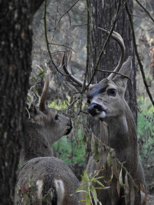
In this photo you see two younger bucks sniffing at a branch onto which an older 4-point buck had just rubbed scent from his forehead gland. The gland secretes a scent that communicates the buck's physical maturity, prowess, and whether or not it is old enough to breed. Photo by Mary K. Hanson. NORTHERN CALIFORNIA – Our native populations of Columbian Black-Tailed Deer (Odocoileus hemionus columbianus) communicate with one another in a variety of ways: through visual signals (like head bowing, foot stomping and tail flagging) and through vocalizations.
In fact, some studies have been able to single out ten distinctive sounds the deer make including snorts, grunts, soft bleating sounds from the females, and the kitten-like mewling of the fawns. But for the majority of the time, the deer effectively communicate in silence through scent.
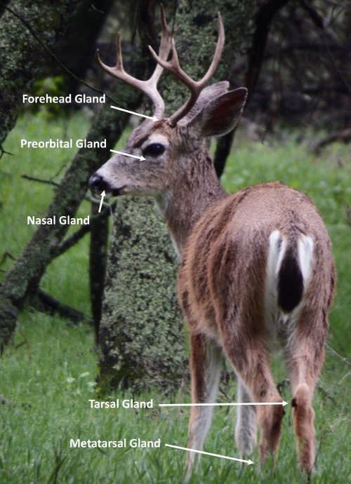
The female black-tailed deer have five scent glands on their bodies and the males have six. Each one is on a distinct spot on the deer’s body and can transmit different kinds of pheromonal information from one individual to another, or from one individual to the entire herd.
The one gland specific to the males is the one on the forehead between the antlers. It secretes a scent that communicates the buck's physical maturity and whether or not it is old enough to breed.
You’ll often see the bucks rubbing their foreheads against trees and other vegetation, marking them with scented advertisements to females and other males in the area.
I once watched a four-point buck rub his scent into the low-hanging branches of a tree, and then saw two younger bucks walk up to the branch to take a whiff.
There are also several glands on the deer’s legs. One is on the inside of the hind legs at the knee (called the tarsal gland) and another is on the outside of the rear legs down near the foot (called the metatarsal gland). The tarsal gland broadcasts the deer’s overall health, its sex, and its status.
You’ll often see deer squat to urinate and allow the urine to flow over this gland. That produces a special odiferous mixture that also identifies the deer as an individual. Your pet dog has a gland that’s somewhat similar to this in function on the rim of its anus (which is why dogs sniff one another at that spot).
During the rutting season (which is taking place right about now in the region) the information in that urine-tinted scent is vital. It lets the bucks know which females are mature enough and ready to breed.
This is a buck with his upper lip curled back in what is commonly known as the “flehmen sniff.” He closes his nostrils and pulls air in and over the "vomeronasal organ" in the roof of his mouth to pick up on the pheromones of the females around him to learn if they're in estrus or not. He lifts his top lip because the intake part of the organ is just behind his upper front teeth. Photo by Mary K. Hanson. You’ll often see the bucks with their upper lip curled back in what is commonly known as the “flehmen sniff,” following after females. In the “sniff”, the buck will pull in a sharp breath of air and run that breath over the vomeronasal organ in the roof of his mouth which can translate the different parts of the scent for him.
The most interesting of the leg-sided glands, though, may be the metatarsal gland. This one actually produces an “alarm scent” that silently communicates the presence of danger to the other deer in the group.
When one deer spots a potential predator – like a nearby coyote – its body releases the alarm scent and within seconds every other deer around it is on the lookout and ready to bolt … and no one has uttered a sound.
There is yet another gland between the toes of the deer’s front hooves called the interdigital gland. This gland leaves a tiny spot of scent on the ground every time the deer steps down on it which allows other deer to follow where it’s travel.
Other scent glands can be found at the base of each eye (the preorbital gland) and inside each nostril. These are thought to communicate scents between parents and offspring during the grooming process, and also help with lubricating sensitive eye and nose tissues.
Scent also plays an important role in the bonding process between does and their fawns. Studies indicate that fawns don’t immediately recognize their mothers and will follow after any deer that walks by during their first few days of life.
The mother-fawn bond itself develops slowly through nursing and mutual grooming and the sharing of scent signals. Some theories also suggest that mothers may recognize their fawns during this pre-bonding phase, in part, by the spot-patterns on the fawn’s bodies.
Although those theories are somewhat suspect, it is true that fawns’ spots are unique to each individual, like fingerprints.
When you consider all of the different ways the deer communicate with one another – through sound, sight, and scent – it’s obvious that when all else fails, their noses know.
Mary K. Hanson is a Certified California Naturalist, author, nature photographer and blogger (https://chubbywomanwalkabout.com/). She also teaches naturalist classes through Tuleyome, a 501(c)(3) nonprofit conservation organization based in Woodland, Calif. For more information, see their Web site at www.tuleyome.org.
This image of a male Columbian Black-Tailed Deer shows the placement of five of its six scent glands. The one missing from this image is the interdigital gland between the toes of the front feet. (Females only have five scent glands and are missing the one on the forehead.) Photo by Mary K. Hanson.
LAKEPORT, Calif. – The holiday season had its official kickoff on Saturday night with the annual lighting of the Christmas tree in downtown Lakeport’s Museum Park.
The tree lighting capped off the Dickens Faire and Christmas Market, held Saturday.
Hundreds of people gathered around the tree, in front of the Courthouse Museum, while My Divas sang Christmas carols.
The tree was then lit for the coming Christmas season.
The video above shows the market and the Saturday night tree lighting.
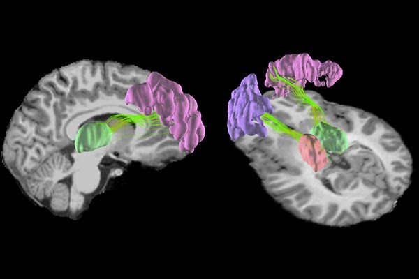
Magnetic resonance imaging (MRI) brain scans have revealed that playing a single season of high school football can cause microscopic changes the grey matter in young players’ brains. These changes are located in the front and rear of the brain, where impacts are most likely to occur, as well as deep inside the brain. Image by Nan-Jie Gong and Chunlei Liu, UC Berkeley. A single season of high school football may be enough to cause microscopic changes in the structure of the brain, according to a new study by researchers at the University of California, Berkeley, Duke University and the University of North Carolina at Chapel Hill.
The researchers used a new type of magnetic resonance imaging (MRI) to take brain scans of 16 high school players, ages 15 to 17, before and after a season of football.
They found significant changes in the structure of the grey matter in the front and rear of the brain, where impacts are most likely to occur, as well as changes to structures deep inside the brain.
All participants wore helmets, and none received head impacts severe enough to constitute a concussion.
The study, which is the cover story of the November issue of Neurobiology of Disease, is one of the first to look at how impact sports affect the brains of children at this critical age.
“It is becoming pretty clear that repetitive impacts to the head, even over a short period of time, can cause changes in the brain,” said study senior author Chunlei Liu, a professor of electrical engineering and computer sciences and a member of the Helen Wills Neuroscience Institute at UC Berkeley. “This is the period when the brain is still developing, when it is not mature yet, so there are many critical biological processes going on, and it is unknown how these changes that we observe can affect how the brain matures and develops.”
Concerning trends
One bonk to the head may be nothing to sweat over. But mounting evidence shows that repeated blows to the cranium – such as those racked up while playing sports like hockey or football, or through blast injuries in military combat – may lead to long-term cognitive decline and increased risk of neurological disorders, even when the blows do not cause concussion.
Over the past decade, researchers have found that an alarming number of retired soldiers and college and professional football players show signs of a newly identified neurodegenerative disease called chronic traumatic encephalopathy, or CTE, which is characterized by a buildup of pathogenic tau protein in the brain.
Though still not well understood, CTE is believed to cause mood disorders, cognitive decline and eventually motor impairment as a patient ages. Definitive diagnosis of CTE can only be made by examining the brain for tau protein during an autopsy.
These findings have raised concern over whether repeated hits to the head can cause brain damage in youth or high school players, and whether it is possible to detect these changes at an early age.
“There is a lot of emerging evidence that just playing impact sports actually changes the brain, and you can see these changes at the molecular level in the accumulations of different pathogenic proteins associated with neurodegenerative diseases like Parkinson’s and dementia,” Liu said. “We wanted to know when this actually happens – how early does this occur?”
A matter of grey and white
The brain is built of white matter, long neural wires that pass messages back and forth between different brain regions, and grey matter, tight nets of neurons that give the brain its characteristic wrinkles.
Recent MRI studies have shown that playing a season or two of high school football can weaken white matter, which is mostly found nestled in the interior of the brain. Liu and his team wanted to know if repetitive blows to the head could also affect the brain’s grey matter.
“Grey matter in the cortex area is located on the outside of the brain, so we would expect this area to be more directly connected to the impact itself,” Liu said.
The researchers used a new type of MRI called diffusion kurtosis imaging to examine the intricate neural tangles that make up grey matter. They found that the organization of the grey matter in players’ brains changed after a season of football, and these changes correlated with the number and position of head impacts measured by accelerometers mounted inside players’ helmets.
The changes were concentrated in the front and rear of the cerebral cortex, which is responsible for higher-order functions like memory, attention and cognition, and in the centrally located thalamus and putamen, which relay sensory information and coordinate movement.
“Although our study did not look into the consequences of the observed changes, there is emerging evidence suggesting that such changes would be harmful over the long term,” Liu said.
Tests revealed that students’ cognitive function did not change over the course of the season, and it is yet unclear whether these changes in the brain are permanent, the researchers say.
“The brain microstructure of younger players is still rapidly developing, and that may counteract the alterations caused by repetitive head impacts,” said first author Nan-Ji Gong, a postdoctoral researcher in the Department of Electrical Engineering and Computer Sciences at UC Berkeley.
However, the researchers still urge caution – and frequent cognitive and brain monitoring – for youth and high schoolers engaged in impact sports.
“I think it would be reasonable to debate at what age it would be most critical for the brain to endure these sorts of consequences, especially given the popularity of youth football and other sports that cause impact to the brain,” Liu said.
Co-authors are Samuel Kuzminski of the University of Oklahoma; Michael Clark, Melissa Fraser and Kevin Guskiewicz of the University of North Carolina at Chapel Hill; Mark Sundman of the University of Arizona; and Jeffrey R. Petrella of the Duke University School of Medicine.
For the past two weeks NASA scientists and satellite data analysts have been working every day producing maps and damage assessments that can be used by disaster managers battling the Woolsey fire near Los Angeles and the Camp fire in Northern California.
The agencywide effort also deployed a research aircraft over the Woolsey fire on Nov. 15 to identify burned areas at risk of mudslides in advance of winter rains expected in the area.
Spearheaded by NASA's Disasters Program in the Earth Science Division, the team produces a variety of data products largely derived from satellite observations, including maps showing the locations of active fires, damage caused by fires, and burned areas that are susceptible to landslides and mudslides.
These products are distributed to agencies working on the ground in California, including the state National Guard, Cal Fire, the Governor's Office of Emergency Services, the California Earthquake Clearinghouse and the Federal Emergency Management Agency.
On Nov. 15, 2018, NASA’s C-20A aircraft took off from its base at NASA's Armstrong Flight Research Center Building 703 in Palmdale, California, carrying the Uninhabited Aerial Vehicle Synthetic Aperture Radar, or UAVSAR.
The instrument, developed and operated by NASA's Jet Propulsion Laboratory, observed and mapped fire scar in the areas affected by the Woolsey fire. The goal was to identify areas at risk of catastrophic mudslides in the coming winter rains.
NASA's Disasters Program mobilizes for intensive risk events globally, including earthquakes, wildfires, floods and severe weather. The program capitalizes on the wealth of environmental data gathered by Earth-observing satellites and other remote-sensing technology to help emergency response managers prepare for, respond to and recover from disasters. In 2017, the program responded to 89 events.
"When disasters occur, our researchers become providers and distributors of images, data and damage assessments," said David Green, manager of the Disasters Program at NASA Headquarters in Washington. "We draw on NASA's technical expertise and strong relationships with our partner organizations to provide useful products to disaster managers."
Much of the information is posted to a geographic information system (GIS)-based Disasters Mapping Portal so that datasets can be adapted by response agencies to meet their specific needs.
The NASA team also responds to requests from agencies for specific information. For example, the Earthquake Clearinghouse asked for help identifying areas at risk, particularly areas where the wildfires are close to critical infrastructure, to help prioritize their response targets.
The Advanced Rapid Imaging and Analysis, or ARIA, team at NASA's Jet Propulsion Laboratory in Pasadena, California, quickly turned around a new "damage proxy map" derived from synthetic aperture radar images from European satellites.
The GIS team, in turn, made the data more user-friendly so that California officials could identify how close the most severely damaged areas were to critical infrastructure like bridges and cellphone towers.
Phil Beilin, information technology lead for the Earthquake Clearinghouse, found the data products NASA provided extremely helpful in his response efforts. With a standard online analysis tool, he was able to filter data from the damage proxy map to see the distance to critical infrastructure, such as a water treatment plant near the Woolsey fire.
"Being able to prioritize what to check in the field is very important, and this GIS format goes a long way to help that process, Beilin said. These data were also shared with the California Office of Emergency Services, Cal Fire, the California Environmental Protection Agency and the California National Guard.
NASA's mobilization in response to the California fires also involved deploying a research aircraft on Nov. 15 for a nighttime flight over the Woolsey fire. The NASA C-20 aircraft carried sensors to map the fire scar, with a goal of identifying areas at risk of catastrophic mudslides in the coming winter rains.
The flight was at night to stay out of the way of firefighting aircraft in the area. The aircraft took off from its base at NASA's Armstrong Flight Research Center in Palmdale, California, carrying the Uninhabited Aerial Vehicle Synthetic Aperture Radar (UAVSAR), developed and operated by JPL. The instrument can "see" through smoke, clouds and the dark of night.
UAVSAR data are often used by scientists to map ground elevation beneath the aircraft to study tectonic motion, but they can also be processed to map fire scars. The radar signals bounce off burned, barren terrain differently than they do from unburned, brush-covered hillsides.
Andrea Donnellan of JPL used the instrument last year to image the fire scar from the Thomas fire and the ensuing Montecito debris flows. She has been experimenting with combining that imagery with optical and thermal cameras. She emailed NASA Headquarters on Nov. 12, pointing out that the flight lines UAVSAR has been flying over the fire area and suggesting a priority order for new fire observations.
"We quickly changed the flight missions we had planned on doing, redesigned where we were going to fly, and put this plan together to fly over these fires," said NASA Armstrong research pilot Dean Neely, who was in charge of preparing the C-20A aircraft that carries UAVSAR.
The resulting UAVSAR image of the 150-square-mile (241-square-kilometer) fire area shows the fire scar, including where vegetation has burned off steep slopes, destabilizing them and increasing the potential for mud and debris flows. With rain in the forecast, this information is timely.
Debris flows triggered by rainstorms after fires sometimes claim more lives than the fires themselves, as happened after last year's Thomas fire in Montecito, about 40 miles west of the Woolsey fire.
The UAVSAR data are shared by the Disasters Program team with agencies including Cal Fire, the U.S. Geological Survey, U.S. Forest Service, and the National Park Service.
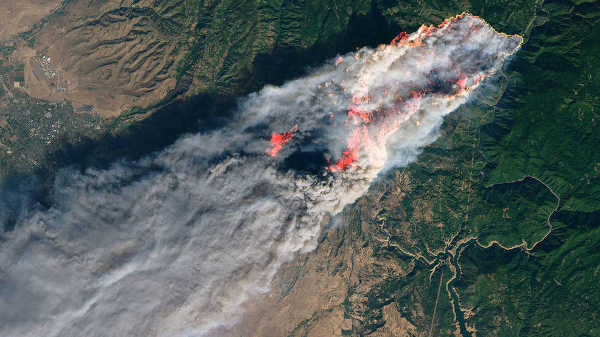
The Camp fire in Paradise, Calif., on Thursday, November 8, 2018, from the Landsat 8 satellite. Credits: USGS/NASA/Joshua Stevens
MIDDLETOWN, Calif. – Highway 29 was closed for a few hours late Saturday and into early Sunday due to a fatal head-on collision that occurred near Middletown.
The crash, which occurred on Highway 29 just south of Grange Road, was first reported just before 10:30 p.m. according to the scanner and California Highway Patrol reports.
The CHP said a truck and a car were involved in the wreck.
Medics arriving minutes after dispatch found that one person had died and a second person was seriously injured and needed to be extricated from a vehicle. No other individuals were reported to have been involved.
Requests for air ambulances were not filled due to concerns about weather, according to dispatch.
Information was not available early Sunday as to the condition of the second injured person, who medics were reported to be working on at the scene.
The CHP confirmed that the wreck was a fatal and that Highway 29 was to be closed while the scene was cleared.
The highway had reopened shortly before 1 a.m. Sunday, the CHP said.
Additional information will be posted as it becomes available.
Email Elizabeth Larson at This email address is being protected from spambots. You need JavaScript enabled to view it.. Follow her on Twitter, @ERLarson, or Lake County News, @LakeCoNews.
LAKEPORT, Calif. – Lake County Animal Care and Control is offering nearly two dozen dogs of all kinds for adoption as the week gets started.
Dogs available for adoption this week include mixes of American Bulldog, cane corso, chow, Chihuahua, dachshund, Labrador Retriever, pit bull, shepherd and terrier.
Dogs that are adopted from Lake County Animal Care and Control are either neutered or spayed, microchipped and, if old enough, given a rabies shot and county license before being released to their new owner. License fees do not apply to residents of the cities of Lakeport or Clearlake.
If you're looking for a new companion, visit the shelter. There are many great pets hoping you'll choose them.
The following dogs at the Lake County Animal Care and Control shelter have been cleared for adoption (additional dogs on the animal control Web site not listed are still “on hold”).
This male Labrador Retriever is in kennel No. 4, ID No. 11246. Photo courtesy of Lake County Animal Care and Control. Male Labrador Retriever
This male Labrador Retriever has a short tan and white coat.
He already has been neutered.
He’s in kennel No. 4, ID No. 11246.
“Raider” is a male pit bull terrier mix in kennel No. 9a, ID No. 11429. Photo courtesy of Lake County Animal Care and Control. ‘Raider’
“Raider” is a male pit bull terrier mix.
He has a short black and white coat.
He’s in kennel No. 9a, ID No. 11429.
“Lona” is a female pit bull terrier in kennel No. 9b, ID No. 11430. Photo courtesy of Lake County Animal Care and Control. ‘Lona’
“Lona” is a female pit bull terrier with a short black and white coat.
She’s in kennel No. 9b, ID No. 11430.
This male terrier in kennel No. 10, ID No. 11427. Photo courtesy of Lake County Animal Care and Control. Male terrier
This male terrier has a short brown and brindle coat.
He’s in kennel No. 10, ID No. 11427.
This male pit bull mix is in kennel No. 11, ID No. 11402. Photo courtesy of Lake County Animal Care and Control. Pit bull mix
This male pit bull mix has a short gray and white coat.
He’s in kennel No. 11, ID No. 11402.
This male pit bull is in kennel No. 12, ID No. 7002. Photo courtesy of Lake County Animal Care and Control. Male pit bull
This male pit bull has a short brown brindle coat.
He already has been neutered.
He’s in kennel No. 12, ID No. 7002.
This female Labrador Retriever in kennel No. 13, ID No. 11424. Photo courtesy of Lake County Animal Care and Control. Female Labrador Retriever
This female Labrador Retriever has a short brown coat.
He’s in kennel No. 13, ID No. 11424.
“Zara” is a female pit bull-Chihuahua mix in kennel No. 14, ID No. 11337. Photo courtesy of Lake County Animal Care and Control. ‘Zara’
“Zara” is a female pit bull-Chihuahua mix with a short brown and brindle coat.
She has already been altered.
She is in kennel No. 14, ID No. 11337.
This male Chihuahua is in kennel No. 15, ID No. 11375. Photo courtesy of Lake County Animal Care and Control. Male Chihuahua
This male Chihuahua has a short black coat.
He’s in kennel No. 15, ID No. 11375.
This male Chihuahua is in kennel No. 16a, ID No. 11321. Photo courtesy of Lake County Animal Care and Control. Male Chihuahua
This male Chihuahua has a short tan and white coat.
He already has been neutered.
He’s in kennel No. 16a, ID No. 11321.
This male Chihuahua-dachshund mix is in kennel No. 16b, ID No. 11322. Photo courtesy of Lake County Animal Care and Control. Chihuahua-dachshund mix
This male Chihuahua-dachshund mix has a medium-length brown and black coat.
He already has been neutered.
He’s in kennel No. 16b, ID No. 11322.
This female Labrador Retriever is in kennel No. 18, ID No. 11239. Photo courtesy of Lake County Animal Care and Control. Female Labrador Retriever
This female Labrador Retriever has a medium-length black coat with white markings.
She already has been spayed.
She’s in kennel No. 18, ID No. 11239.
This young male shepherd is in kennel No. 20, ID No. 11385. Photo courtesy of Lake County Animal Care and Control. Male shepherd
This young male shepherd has a short brindle coat with white markings.
He’s in kennel No. 20, ID No. 11385.
“Gem” is a female pit bull terrier in kennel No. 21, ID No. 11396. Photo courtesy of Lake County Animal Care and Control. ‘Gem’
“Gem” is a female pit bull terrier with a short brindle and white coat.
She already has been spayed.
She’s in kennel No. 21, ID No. 11396.
This female pit bull terrier is in kennel No. 23, ID No. 10226. Photo courtesy of Lake County Animal Care and Control. ‘Molly’
“Molly” is a female pit bull terrier.
She already has been spayed.
She’s in kennel No. 23, ID No. 10226.
“Saint” is a male American Bulldog-pit bull terrier mix in kennel No. 24, ID No. 11236. Photo courtesy of Lake County Animal Care and Control. ‘Saint’
“Saint” is a male American Bulldog-pit bull terrier mix.
He has a short blue and brindle coat.
He’s in kennel No. 24, ID No. 11236.
This female Labrador Retriever is in kennel No. 26, ID No. 11399. Photo courtesy of Lake County Animal Care and Control. Female Labrador Retriever
This female Labrador Retriever has a shaved black coat.
She’s in kennel No. 26, ID No. 11399.
This female Labrador Retriever is in kennel No. 27, ID No. 11400. Photo courtesy of Lake County Animal Care and Control. Female Labrador Retriever
This female Labrador Retriever has a short gray coat.
She’s in kennel No. 27, ID No. 11400.
This female chow chow-shepherd mix is in kennel No. 28, ID No. 11421. Photo courtesy of Lake County Animal Care and Control. Chow chow-shepherd mix
This female chow chow-shepherd mix has a medium-length orange coat.
She’s in kennel No. 28, ID No. 11421.
“Hazel” is a female cane corso mastiff-pit bull terrier mix in kennel No. 30, ID No. 11439. Photo courtesy of Lake County Animal Care and Control. ‘Hazel’
“Hazel” Is a female cane corso mastiff-pit bull terrier mix.
She has a short blue coat.
She’s in kennel No. 30, ID No. 11439.
This male pit bull terrier is in kennel No. 33, ID No. 11345. Photo courtesy of Lake County Animal Care and Control. Male pit bull terrier
This male pit bull terrier has a short gray and brown coat.
He’s in kennel No. 33, ID No. 11345.
This female pit bull terrier is in kennel No. 34, ID No. 11428. Photo courtesy of Lake County Animal Care and Control.Female pit bull terrier
This female pit bull terrier has a short tan and white coat.
She’s in kennel No. 34, ID No. 11428.
Lake County Animal Care and Control is located at 4949 Helbush in Lakeport, next to the Hill Road Correctional Facility.
Office hours are Monday through Friday, 11 a.m. to 5 p.m., and 11 a.m. to 3 p.m., Saturday. The shelter is open from 11 a.m. to 4 p.m. Monday through Friday and on Saturday from 11 a.m. to 3 p.m.
For more information call Lake County Animal Care and Control at 707-263-0278.
Email Elizabeth Larson at This email address is being protected from spambots. You need JavaScript enabled to view it.. Follow her on Twitter, @ERLarson, or Lake County News, @LakeCoNews.
Peter C. Mancall, University of Southern California – Dornsife College of Letters, Arts and Sciences
‘Mayflower in Plymouth Harbor’ by William Halsall (1882). Pilgrim Hall Museum
Sometime in the autumn of 1621, a group of English Pilgrims who had crossed the Atlantic Ocean and created a colony called New Plymouth celebrated their first harvest.
They hosted a group of about 90 Wampanoags, their Algonquian-speaking neighbors. Together, migrants and Natives feasted for three days on corn, venison and fowl.
In their bountiful yield, the Pilgrims likely saw a divine hand at work.
As Gov. William Bradford wrote in 1623, “Instead of famine now God gave them plenty, and the face of things was changed, to the rejoicing of the hearts of many, for which they blessed God.”
But my recent research on the ways Europeans understood the Western Hemisphere shows that – despite the Pilgrims’ version of events – their survival largely hinged on two unrelated developments: an epidemic that swept through the region and a repository of advice from earlier explorers.
A ‘desolate wilderness’ or ‘Paradise of all parts’?
Bradford’s “Of Plymouth Plantation,” which he began to write in 1630 and finished two decades later, traces the history of the Pilgrims from their persecution in England to their new home along the shores of modern Boston Harbor.
William Bradford’s writings depicted a harrowing, desolate environment.
Bradford and other Pilgrims believed in predestination. Every event in their lives marked a stage in the unfolding of a divine plan, which often echoed the experiences of the ancient Israelites.
Throughout his account, Bradford probed Scripture for signs. He wrote that the Puritans arrived in “a hideous and desolate wilderness, full of wild beasts and wild men.” They were surrounded by forests “full of woods and thickets,” and they lacked the kind of view Moses had on Mount Pisgah, after successfully leading the Israelites to Canaan.
Drawing on chapter 26 of the Book of Deuteronomy, Bradford declared that the English “were ready to perish in this wilderness,” but God had heard their cries and helped them. Bradford paraphrased from Psalm 107 when he wrote that the settlers should “praise the Lord” who had “delivered them from the hand of the oppressor.”
If you were reading Bradford’s version of events, you might think that the survival of the Pilgrims’ settlements was often in danger. But the situation on the ground wasn’t as dire as Bradford claimed.
The French explorer Samuel de Champlain depicted Plymouth as a region that was eminently inhabitable.Source., Author provided
Earlier European visitors had described pleasant shorelines and prosperous indigenous communities. In 1605, the French explorer Samuel de Champlain sailed past the site the Pilgrims would later colonize and noted that there were “a great many cabins and gardens.” He even provided a drawing of the region, which depicted small Native towns surrounded by fields.
About a decade later Captain John Smith, who coined the term “New England,” wrote that the Massachusetts, a nearby indigenous group, inhabited what he described as “the Paradise of all those parts.”
‘A wonderful plague’
Champlain and Smith understood that any Europeans who wanted to establish communities in this region would need either to compete with Natives or find ways to extract resources with their support.
But after Champlain and Smith visited, a terrible illness spread through the region. Modern scholars have argued that indigenous communities were devastated by leptospirosis, a disease caused by Old World bacteria that had likely reached New England through the feces of rats that arrived on European ships.
The absence of accurate statistics makes it impossible to know the ultimate toll, but perhaps up to 90 percent of the regional population perished between 1617 to 1619.
To the English, divine intervention had paved the way.
“By God’s visitation, reigned a wonderful plague,” King James’ patent for the region noted in 1620, “that had led to the utter Destruction, Devastacion, and Depopulation of that whole territory.”
The epidemic benefited the Pilgrims, who arrived soon thereafter: The best land had fewer residents and there was less competition for local resources, while the Natives who had survived proved eager trading partners.
The wisdom of those who came before
Just as important, the Pilgrims understood what to do with the land.
By the time that these English planned their communities, knowledge of the Atlantic coast of North America was widely available.
Those hoping to create new settlements had read accounts of earlier European migrants who had established European-style villages near the water, notably along the shores of Chesapeake Bay, where the English had founded Jamestown in 1607.
These first English migrants to Jamestown endured terrible disease and arrived during a period of drought and colder-than-normal winters. The migrants to Roanoke on the outer banks of Carolina, where the English had gone in the 1580s, disappeared. And a brief effort to settle the coast of Maine in 1607 and 1608 failed because of an unusually bitter winter.
Many of these migrants died or gave up. But none disappeared without record, and their stories circulated in books printed in London. Every English effort before 1620 had produced accounts useful to would-be colonizers.
The most famous account, by the English mathematician Thomas Harriot, enumerated the commodities that the English could extract from America’s fields and forests in a report he first published in 1588.
The artist John White, who was on the same mission to modern Carolina, painted a watercolor depicting the wide assortment of marine life that could be harvested, another of large fish on a grill, and a third showing the fertility of fields at the town of Secotan. By the mid-1610s, actual commodities had started to arrive in England too, providing support for those who had claimed that North American colonies could be profitable. The most important of these imports was tobacco, which many Europeans considered a wonder drug capable of curing a wide range of human ailments.
These reports (and imports) encouraged many English promoters to lay plans for colonization as a way to increase their wealth. But those who thought about going to New England, especially the Pilgrims who were kindred souls of Bradford, believed that there were higher rewards to be reaped.
Bradford and the other Puritans who arrived in Massachusetts often wrote about their experience through the lens of suffering and salvation.
But the Pilgrims were better equipped to survive than they let on.


 ‘Mayflower in Plymouth Harbor’ by William Halsall (1882).
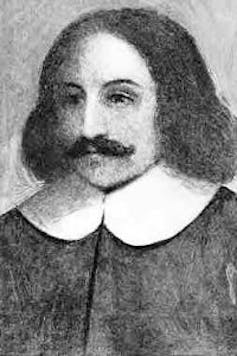


