- Alex Sosnowski
- Posted On
WEATHER: No relief in sight from California wildfire risk
AccuWeather.com reports the ongoing drought will continue to keep the fire danger elevated in California indefinitely into the summer.
While a storm system was bringing showers to parts of the Northwest on Wednesday, no rainfall is forecast to reach central and Southern California through the weekend and beyond.
Moisture from Amanda, now diminishing over the Eastern Pacific, will not reach the state.
Weather fairly typical of California for late May and early June will continue into next week with areas of low clouds yielding to sunshine on the coast and sunshine all day across the interior.
According to Western Weather Expert Ken Clark, “In California, there will be slight cooling this weekend, followed by a warming trend next week, but the risk of wildfires will continue.”
Very little rainfall typically occurs in California this time of the year, and when it does occur it tends to be very sporadic.
“The problem has been, and will continue to be, associated with the lack of rainfall and mountain snow over the winter,” Clark said.
Since Nov. 1, 2013, many areas in California have received less than half their normal precipitation.
As a result, the brush is very dry and more typical of late summer, when there is an uptick in wildfires.
A large fire broke out on Memorial Day in Mariposa County, California. The blaze, known as the Hunters Fire, began near the Hunters Valley Access Road in the Bear Valley area.
According to Cal Fire, as of late Wednesday, the fire had consumed 677 acres, threatened 100 residences and was only 40 percent contained. The cause of the fire is under investigation.
A breeze averaging 10 to 20 miles per hour from the northwest can cause problems for firefighters on Saturday in Mariposa County. While light winds are generally forecast during most other days, large fires can generate their own wind and can be unpredictable.
There have been more than 1,700 wildfires in California since the start of the year, which have burned more than 15,000 acres.
For the year to date, compared to the five-year average, the number of California fires is nearly double and the amount of acres that have burned is more than double.
Fires have scorched other parts of the Southwest this spring.
The Slide Fire close to Slide Rock State Park, in the Flagstaff, Arizona, area continued to burn Wednesday.
According to InciWeb on Wednesday night, the fire has consumed more than 20,000 acres and was 45 percent contained. The blaze was reported on May 20, and the cause is under investigation.
While a developing El Niño typically brings a bumper crop of tropical systems over the Eastern Pacific during the summer, a direct visit by a tropical storm is extremely rare in California.
The warmer-than-average water temperatures of the tropical Pacific Ocean produced by an El Niño pattern cause changes in steering winds around the globe.
According to AccuWeather Long Range Expert Paul Pastelok, “There is a chance that some moisture comes in from the tropics later in the summer, but rainfall would tend to be very spotty.”
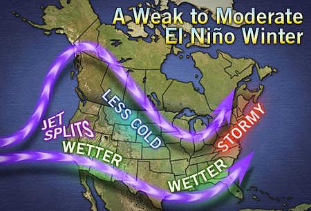
Winter is a long way off, but there is some hope that the developing El Niño will deliver much needed rain to the region.
“Depending on the strength of the El Niño, the winter weather pattern produced could make for more frequent and stronger storms moving in from the Pacific along the West coast of the United States this winter, which would translate to more rain than last winter,” Pastelok said.
A long drought and fire season lies ahead until then.
Alex Sosnowski is an expert senior meteorologist for www.AccuWeather.com .