California Highway Patrol Deputy Commissioner Amanda L. Ray. Courtesy photo. In a historical appointment, the California Highway Patrol has appointed the first African American woman to hold its second-in-command post.
On Friday, CHP Commissioner Warren Stanley announced his appointment of Assistant Commissioner Amanda L. Ray as deputy commissioner.
The appointment makes Deputy Commissioner Ray the first African American woman in the department’s 91-year history to hold the position of second in command of the nation’s largest state police agency.
Gov. Gavin Newsom, who last year reappointed Commissioner Stanley – who also is African American – to his post, applauded Friday’s announcement.
“The CHP is one of the most respected law enforcement agencies in California, if not the nation. As we mark Black History Month and Women’s History Month in March, I couldn’t be prouder of Deputy Commissioner Ray’s accomplishments and contributions to making the CHP the best of the best. Californians have every reason to be confident in the leadership of the CHP,” Newsom said.
Deputy Commissioner Ray stated she was “honored and humbled” to be appointed to her new post.
“I am grateful to continue to serve alongside the amazing women and men who each day are dedicated to providing the highest level of Safety, Service, and Security to the people of California,” she said. “I look forward to continuing to make the Department one that our employees and the people of this great state can admire and be proud of.”
A native of Oakland, Deputy Commissioner Ray, 53, is a 30-year member of the department, rising through the ranks and serving in assignments of increasing responsibility from cadet to assistant commissioner, staff, where she oversaw the administrative functions of the department, to include a $2.8 billion budget, departmental training, information technology, and personnel administration of a statewide organization of 11,000 women and men.
In her new role, Deputy Commissioner Ray will oversee the day to day operations, the administrative and field operations of the CHP as well as the Offices of Legal Affairs, Internal Affairs, Equal Employment Opportunity, Risk Management, the Office of Accreditation, and Community Outreach and Media Relations.
Deputy Commissioner Ray succeeds Scott Silsbee, who retired from the CHP in December.
California Highway Patrol Deputy Commissioner Amanda L. Ray career highlights:
CHP / Academy: 03/12/90, cadet CHP / South Los Angeles Area: 08/09/90, officer CHP / Santa Fe Springs Area: 12/02/99, sergeant CHP / Santa Fe Springs Area: 04/01/03, lieutenant CHP / Riverside Area: 07/01/06, lieutenant CHP / Hayward Area: 09/01/11, captain CHP / Riverside Area: 10/31/12, captain CHP / Golden Gate Division: 09/01/15, assistant chief CHP / Inland Division: 03/02/17, assistant chief CHP / Assistant Commissioner, staff: 10/01/17, chief CHP / Assistant Commissioner, staff: 04/01/18, assistant commissioner, staff
The California Department of Public Health announced today that new Centers for Disease Control test kits used to detect Coronavirus Disease 2019, or COVID-19, now available in California can be used to do diagnostic testing in the community.
California will immediately receive an additional shipment of kits to test up to 1,200 people.
“These new testing protocols and resources will help California medical experts identify and treat COVID-19 cases, trace potential exposures and better protect public health,” said Gov. Gavin Newsom. “I am grateful to the CDC and federal government for quickly heeding our state’s requests and assisting California’s response to this evolving situation.”
“The availability to test at California’s public health laboratories is a significant step forward in our ability to respond rapidly to this evolving situation,” said Dr. Sonia Angell, director of the California Department of Public Health and State Health Officer. “As we face the likelihood of community transmission here in California, having this resource where we need it, is essential to better inform public health response and protect our communities.”
The California Department of Public Health has been prepared and is continuing with the following actions as the situation surrounding COVID-19 evolves:
– Activating the Emergency Operations Center to coordinate response efforts across the state. – Continuing to prepare and respond in coordination with federal and local partners, hospitals and physicians. – Deploying staff to assist with contact tracing in Solano and Sacramento counties for a patient whose source of infection is unknown. – Providing information, guidance documents, and technical support to local health departments, health care facilities, providers, schools, universities, colleges, and childcare facilities across California. – Coordinating with federal authorities and local health departments that have implemented screening, monitoring and, in some cases quarantine. – Engaging with local health departments in managing suspect and confirmed cases of COVID-19 patients over the past several weeks.
Beyond the work of health officials, each and every person can take steps to reduce the risk of becoming infected with this virus.
– Washing hands with soap and water. – Avoiding touching eyes, nose or mouth with unwashed hands. – Avoiding close contact with people who are sick. – Staying away from work, school or other people if you become sick with respiratory symptoms like fever and cough. – Follow guidance from public health officials.
If a person develops symptoms of COVID-19 including fever, cough or shortness of breath, and has reason to believe they may have been exposed, they should call their health care provider or local health department before seeking care. Contacting them in advance will make sure that people can get the care they need without putting others at risk.
For more information about novel coronavirus including various resources, please visit the CDPH website.
NORTH COAST, Calif. – The Mendocino National Forest said acreage has grown and containment remains steady on the Baseball fire burning on the Covelo Ranger District.
The fire, located 15 miles southeast of Covelo in Glenn and Mendocino counties, reached 140 acres on Friday, with containment at 50 percent, the forest reported.
Officials said the increase in acreage is the result of a firing operation on Thursday where crews burned the vegetation between the main fire and an established handline to contain the fire.
There are about 100 personnel on the incident including engines and crews from the Mendocino, Klamath and Six Rivers national forests and from Oregon.
On Friday, personnel continued to mop-up and patrol the fire, forest officials said.
It has been determined that the Baseball fire started on Tuesday from previous pile burning on the Baseball prescribed fire project.
The fire is burning in grass, brush and timber in steep, rugged terrain at a low to moderate rate in a mosaic pattern, similar to the desired effects from a prescribed fire.
There are no immediate threats to property or structures.
Dennis Fordham. Courtesy photo. Money on deposit in bank or brokerage accounts that are titled as “joint tenancy with right of survivorship” passes automatically at the death of a deceased joint tenant to the surviving joint tenants, if any, by operation of law; or does it?
Many times the money is deposited by one account holder only – often an elderly parent or a dependent spouse. The other joint tenant is added so that they can manage and use the account on behalf of the person who contributed the money.
In California, section 5302(a) of the Probate Code provides that, “(a) Sums remaining on deposit at the death of a party to a joint account belong to the surviving party or parties as against the estate of the decedent unless there is clear and convincing evidence of a different intent.”
Section 5302 (e) provides that, “A right of survivorship arising from the express terms of the [joint tenancy] account or under this section, a beneficiary designation in a Totten trust account, or a P.O.D. payee designation, cannot be changed by will.”
Section 5303 of the Probate Code, however, provides that a joint tenancy account can be changed in any of four ways; none of which involves a will.
Until now, I always understood that a decedent’s will had no relevance to a decedent’s joint tenancy bank account when there are surviving joint tenants. That is, unless the joint tenants died simultaneously the will of a deceased joint tenant was not relevant.
Recently, in Placencia v. Strazicich (2019) 42 CA 5th 730, however, California’s Fourth District Court of Appeals decided that the will of a deceased joint tenant can be used as “clear and convincing evidence of a different intent” to negate the right of survivorship, notwithstanding sections 5302 and 5303 (see above).
In Placencia v. Strazicich, a father named Ralph opened a joint Franklin Fund account with Lisa, one of his daughters.
Afterward, Ralph executed a will (11 days prior to his death) in which he said, “Remove Lisa Strazicich as sole beneficiary of my Franklin Fund. I want the beneficiaries to be Lisa Strazicich, Stephanie A. Placencia and Tina R. Placencia, … I want the Franklin Fund to be placed into my trust and then be used to pay off the mortgage curt of my home … .”
After Ralph died, Lisa retitled the money in the account into her own name for herself alone.
The court examined Probate Code sections 5302 and 5303 and decided that although the will could not change the right of survivorship it could nonetheless provide clear and convincing evidence of intent to negate the right of survivorship.
Having thus negated Lisa’s right of survivorship, the court then decided that, “… arguably, therefore, upon Ralph's death, his interest in the Franklin Fund account became part of his personal estate, which would need to be probated.”
In Placencia v. Strazicich, the Court of Appeals bent over backward to give effect to the decedent’s intent even though the statute says that a joint tenancy cannot be changed by a will.
The court justified its sleight of hand based on “… the modern trend in the law favoring the decedent’s intent over [legal] formalities.”
The foregoing legal authority is a California appellate court decision. As such, it is only binding in the Fourth District (certain counties including San Diego) and is not binding statewide.
Eventually, the California Supreme Court may get the opportunity to decide whether the same approach should become the law of California.
Dennis A. Fordham, attorney, is a State Bar-Certified Specialist in estate planning, probate and trust law. His office is at 870 S. Main St., Lakeport, Calif. He can be reached at This email address is being protected from spambots. You need JavaScript enabled to view it. and 707-263-3235.
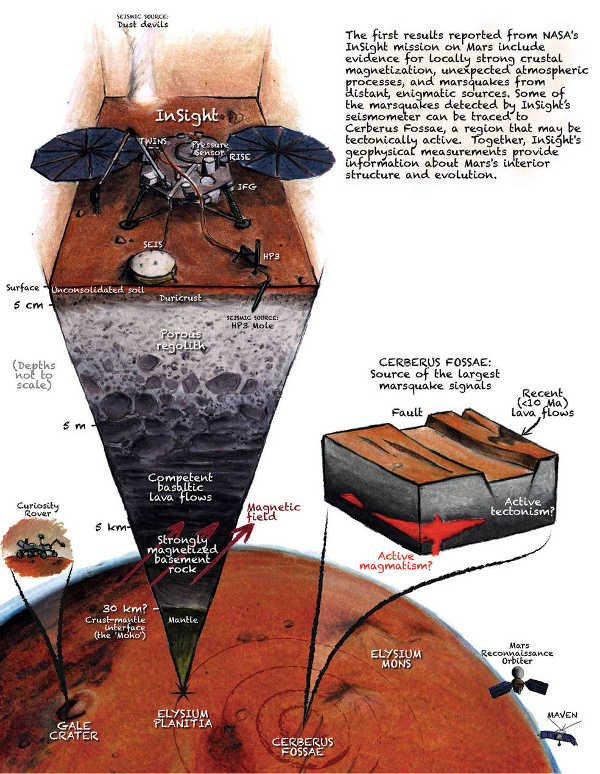
In this artist's concept of NASA's InSight lander on Mars, layers of the planet's subsurface can be seen below and dust devils can be seen in the background. Credits: IPGP/Nicolas Sarter. A new understanding of Mars is beginning to emerge, thanks to the first year of NASA's InSight lander mission.
Findings described in a newly published set of six papers reveal a planet alive with quakes, dust devils and strange magnetic pulses.
Five of the papers were published in Nature. An additional paper in Nature Geoscience details the InSight spacecraft's landing site, a shallow crater nicknamed "Homestead hollow" in a region called Elysium Planitia.
InSight is the first mission dedicated to looking deep beneath the Martian surface. Among its science tools are a seismometer for detecting quakes, sensors for gauging wind and air pressure, a magnetometer, and a heat flow probe designed to take the planet's temperature.
While the team continues to work on getting the probe into the Martian surface as intended, the ultra-sensitive seismometer, called the Seismic Experiment for Interior Structure, or SEIS, has enabled scientists to "hear" multiple trembling events from hundreds to thousands of miles away.
Seismic waves are affected by the materials they move through, giving scientists a way to study the composition of the planet's inner structure. Mars can help the team better understand how all rocky planets, including Earth, first formed.
Underground
Mars trembles more often – but also more mildly – than expected. SEIS has found more than 450 seismic signals to date, the vast majority of which are probably quakes (as opposed to data noise created by environmental factors, like wind).
The largest quake was about magnitude 4.0 in size – not quite large enough to travel down below the crust into the planet's lower mantle and core.
Those are "the juiciest parts of the apple" when it comes to studying the planet's inner structure, said Bruce Banerdt, InSight principal investigator at JPL.
Scientists are ready for more: It took months after InSight's landing in November 2018 before they recorded the first seismic event. By the end of 2019, SEIS was detecting about two seismic signals a day, suggesting that InSight just happened to touch down at a particularly quiet time. Scientists still have their fingers crossed for "the Big One."
Mars doesn't have tectonic plates like Earth, but it does have volcanically active regions that can cause rumbles.
A pair of quakes was strongly linked to one such region, Cerberus Fossae, where scientists see boulders that may have been shaken down cliffsides. Ancient floods there carved channels nearly 800 miles (1,300 kilometers) long.
Lava flows then seeped into those channels within the past 10 million years – the blink of an eye in geologic time.
Some of these young lava flows show signs of having been fractured by quakes less than 2 million years ago. "It's just about the youngest tectonic feature on the planet," said planetary geologist Matt Golombek of JPL. "The fact that we're seeing evidence of shaking in this region isn't a surprise, but it's very cool."
The two largest quakes detected by NASA's InSight appear to have originated in a region of Mars called Cerberus Fossae. Scientists previously spotted signs of tectonic activity here, including landslides. This image was taken by the HiRISE camera on NASA's Mars Reconnaisance Orbiter. Credits: NASA/JPL-Caltech/University of Arizona. At the surface
Billions of years ago, Mars had a magnetic field. It is no longer present, but it left ghosts behind, magnetizing ancient rocks that are now between 200 feet (61 meters) to several miles below ground. InSight is equipped with a magnetometer – the first on the surface of Mars to detect magnetic signals.
The magnetometer has found that the signals at Homestead hollow are 10 times stronger than what was predicted based on data from orbiting spacecraft that study the area. The measurements of these orbiters are averaged over a couple of hundred miles, whereas InSight's measurements are more local.
Because most surface rocks at InSight's location are too young to have been magnetized by the planet's former field, "this magnetism must be coming from ancient rocks underground," said Catherine Johnson, a planetary scientist at the University of British Columbia and the Planetary Science Institute.
"We're combining these data with what we know from seismology and geology to understand the magnetized layers below InSight,” said Johnson. “How strong or deep would they have to be for us to detect this field?"
In addition, scientists are intrigued by how these signals change over time. The measurements vary by day and night; they also tend to pulse around midnight.
Theories are still being formed as to what causes such changes, but one possibility is that they're related to the solar wind interacting with the Martian atmosphere
In the Wind
InSight measures wind speed, direction and air pressure nearly continuously, offering more data than previous landed missions.
The spacecraft's weather sensors have detected thousands of passing whirlwinds, which are called dust devils when they pick up grit and become visible.
“This site has more whirlwinds than any other place we've landed on Mars while carrying weather sensors,” said Aymeric Spiga, an atmospheric scientist at Sorbonne University in Paris.
Despite all that activity and frequent imaging, InSight's cameras have yet to see dust devils. But SEIS can feel these whirlwinds pulling on the surface like a giant vacuum cleaner.
"Whirlwinds are perfect for subsurface seismic exploration," said Philippe Lognonné of Institut de Physique du Globe de Paris, or IPGP, principal investigator of SEIS.
Still to Come: The Core
InSight has two radios: one for regularly sending and receiving data, and a more powerful radio designed to measure the "wobble" of Mars as it spins.
This X-band radio, also known as the Rotation and Interior Structure Experiment, or RISE, can eventually reveal whether the planet's core is solid or liquid. A solid core would cause Mars to wobble less than a liquid one would.
This first year of data is just a start. Watching over a full Martian year (two Earth years) will give scientists a much better idea of the size and speed of the planet's wobble.
About InSight
A division of Caltech in Pasadena, JPL manages InSight for NASA's Science Mission Directorate. InSight is part of NASA's Discovery Program, managed by the agency's Marshall Space Flight Center in Huntsville, Alabama. Lockheed Martin Space in Denver built the InSight spacecraft, including its cruise stage and lander, and supports spacecraft operations for the mission.
A number of European partners, including France's Centre National d'Études Spatiales, CNES, the German Aerospace Center, or DLR, and the United Kingdom Space Agency are supporting the InSight mission.
CNES provided the SEIS instrument to NASA, with the principal investigator at IPGP. Significant contributions for SEIS came from IPGP; the Max Planck Institute for Solar System Research in Germany; the Swiss Federal Institute of Technology in Switzerland; Imperial College London and Oxford University in the United Kingdom; and JPL.
DLR provided the Heat Flow and Physical Properties Package instrument, with significant contributions from the Space Research Center of the Polish Academy of Sciences and Astronika in Poland. Spain's Centro de Astrobiología supplied the temperature and wind sensors.
A cutaway view of Mars showing the InSight lander studying seismic activity. Credits: J.T. Keane/Nature Geoscience.
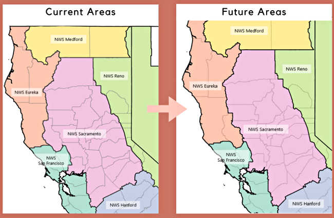
The change in the National Weather Service forecast areas including Lake County, California. Images courtesy of the National Weather Service.
LAKE COUNTY, Calif. – The National Weather Service is preparing to transfer responsibility for Lake County’s forecast service area from its Sacramento to Eureka office.
The transition will take effect on Tuesday, March 3.
The National Weather Service said the transition will necessitate reconfiguring nearby public and fire weather zones.
The agency said both its Eureka and Sacramento offices currently provide fire weather forecasts for different portions of Lake County.
The transition will allow the Eureka office to provide forecast services to all of Caltrans District 1’s service area. In addition, it will give Lake County more focused support for weather emergencies from one National Weather Service office versus having to coordinate with two of them for forecasts and fire weather, the agency reported.
Michelle Mead, warning coordination meteorologist in the National Weather Service’s Sacramento office, said forecasts will continue to published as before at www.weather.gov, with the Eureka office not just handling the main forecasts but also taking charge of issuing flood and storm warnings.
Community members who have followed the National Weather Service’s Sacramento office on Facebook will now also want to follow Eureka, which will share weather updates there.
“We started the discussion last summer with all of the emergency management personnel in Lake County,” Mead said.
Mead said it was an idea that had been “kicked around” for some time, and then Dale Carnathan, the emergency services manager for the Lake County Office of Emergency Services, expressed interest pursuing it.
At that point, Mead said she told him about the option of moving the forecast responsibility from Sacramento to Eureka if it would serve the county better, and eventually the request was made formally.
“There wasn’t any dissatisfaction with the services that we were receiving from Sacramento,” said Teresa Stewart, assistant to the Lake County Office of Emergency Service.
Stewart explained that the agency felt that there were benefits to transferring to Eureka, including being in the same forecast area as Mendocino County, which it works with often. Lake County also shares the same emergency alert system plan with Mendocino County.
She said the emergency alert system for Lake County already is activated by the Eureka office through its weather radio transmitter in Ukiah.
Moving operations to Eureka also will streamline operations. Stewart said there is a small portion of northern Lake County’s forecast coming from Eureka in addition to the rest of the county’s forecast coming from Sacramento.
Stewart and Mead both pointed out that Mendocino and Lake counties have similar weather, and that Lake County is in the California Office of Emergency Services’ 16-county Coastal Region, which the National Weather Service’s Eureka office serves.
Mead said that, weatherwise, Lake County is more in line with the Coastal Range and the west side of the mountains.
Stewart said the county requested a change over in an Aug. 30 letter.
The Lake County Disaster Council would begin discussing the proposal in the fall, according to a meeting agenda.
Mead said National Weather Service representatives attended local meetings and presented the proposal, and everyone was in agreement with it for all of the reasons she explained.
She said it was then open for a 90-day period which concludes with the Tuesday transition.
“We continue to have a great working relationship with Lake County,” said Mead.
Ryan Aylward, Mead’s counterpart in Eureka, where he is a warning coordination meteorologist, has been working with Mead on the transition. That work has included moving over operations and interacting with weather spotters.
This week, Lake County’s weather spotters were notified of the changeover and directed to contact the Eureka office as of March 3.
“It won’t be an extremely large additional workload because we’re already doing a forecast for Mendocino County,” which has an extremely similar climate, Aylward said.
A major concern through the summer is fire weather, an area where Aylward said they are placing a lot of concentration.
When considering Lake County’s membership in the Coastal OES Region, its similar climate and the fact that it’s also a part of Caltrans District 1, headquartered in Eureka, “It makes sense to be with us,” Aylward said.
Email Elizabeth Larson at This email address is being protected from spambots. You need JavaScript enabled to view it.. Follow her on Twitter, @ERLarson, or Lake County News, @LakeCoNews.
CLEARLAKE, Calif. – Clearlake Animal Control has several more new dogs, including puppies, waiting to meet their new families.
The kennels also have many dogs that need to be reunited with their owners. To find the lost/found pet section, click here.
The following dogs are ready for adoption.
“Barkley.” Photo courtesy of Clearlake Animal Control. ‘Barkley’
“Barkley” is a male American Pit Bull Terrier mix with a short red coat.
He is dog No. 3528.
“Blue.” Photo courtesy of Clearlake Animal Control. ‘Blue’
“Blue” is a male pit bull terrier mix with a short white and brindle coat.
He has been neutered.
He is dog No. 3539.
“Cha-Chi.” Photo courtesy of Clearlake Animal Control. ‘Cha-Chi’
“Cha-Chi” is a male Chihuahua with a short gold and white coat.
He is dog No. 3661.
“Duchess.” Photo courtesy of Clearlake Animal Control. ‘Duchess’
“Duchess” is a female Chihuahua puppy with a short tan coat.
She is dog No. 3618.
“Garrett.” Photo courtesy of Clearlake Animal Control. ‘Garrett’
“Garrett” is a male German Shepherd mix with a medium tan and black coat.
He has been neutered.
He is dog No. 3580.
“Nutmeg.” Photo courtesy of Clearlake Animal Control. ‘Nutmeg’
“Nutmeg” is a female German Shepherd mix puppy.
She has a short brown and black coat.
She is dog No. 3628.
“Phoebe.” Photo courtesy of Clearlake Animal Control. ‘Phoebe’
“Phoebe” is a female American Pit Bull Terrier mix with a short black and white coat.
She is dog No. 3483.
“Roxy.” Photo courtesy of Clearlake Animal Control. ‘Roxy’
“Roxy” is a female German Shepherd mix with a medium-length tan and black coat.
She has been spayed.
She is dog No. 3545.
“Tulip.” Photo courtesy of Clearlake Animal Control. ‘Tulip’
“Tulip” is a female Chihuahua puppy mix with a short tan coat.
She is dog No. 3663.
“Woodrow.” Photo courtesy of Clearlake Animal Control. ‘Woodrow’
“Woodrow” is a male Staffordshire Bull Terrier with a black and white coat.
He is dog No. 3281.
Clearlake Animal Control’s shelter is located at 6820 Old Highway 53, off Airport Road.
Hours of operation are noon to 4 p.m. Tuesday through Saturday. The shelter is closed Sundays, Mondays and major holidays; the shelter offers appointments on the days it’s closed to accommodate people.
Call the Clearlake Animal Control shelter at 707-273-9440, or email This email address is being protected from spambots. You need JavaScript enabled to view it. to inquire about adoptions.
Visit Clearlake Animal Control on Facebook or at the city’s Web site.
Email Elizabeth Larson at This email address is being protected from spambots. You need JavaScript enabled to view it.. Follow her on Twitter, @ERLarson, or Lake County News, @LakeCoNews.
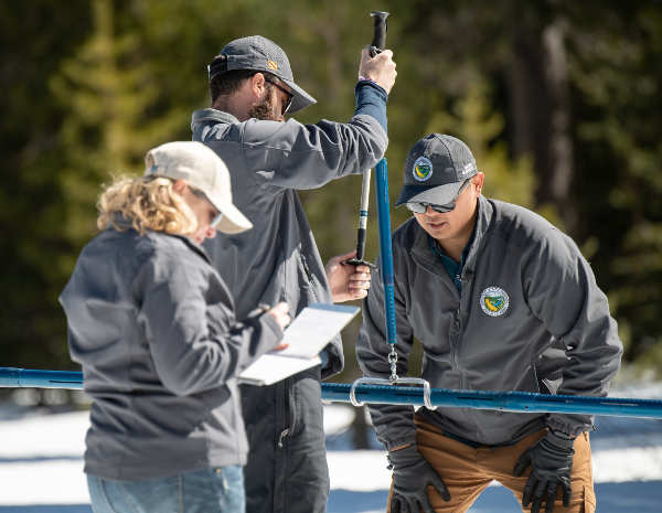
Sean de Guzman (Right), chief of California Department of Water Resources, Snow Surveys and Water Supply Forecasting Section, conducts the third media snow survey of the 2020 season at Phillips Station in the Sierra Nevada Mountains. Nate Burely (center), with DWR’s Water Resources Engineer, Reservoir Coordinated Operations Section, and Molly White (Left), DWR’s Chief of State Water Project Water Operations Office, assist with the survey, which was held approximately 90 miles east of Sacramento off Highway 50 in El Dorado County. Photo taken on Thursday, February 27, 2020. Ken James/California Department of Water Resources. NORTHERN CALIFORNIA – The Department of Water Resources on Thursday conducted the third manual snow survey of 2020 at Phillips Station.
The manual survey recorded 29 inches of snow depth and a snow water equivalent, or SWE, of 11.5 inches, which is 47 percent of the March average for this location.
The SWE measures the amount of water contained in the snowpack, which provides a more accurate forecast of spring runoff.
“Right now, 2020 is on track to be a below-average year but we could still see large storms in March and April that will improve the current snowpack,” said Sean de Guzman, chief of DWR’s Snow Surveys and Water Supply Forecasting Section. “While periods of dry conditions are expected in California, climate change has made them more unpredictable and extreme which is why we must always use the water we have wisely.”
While February has been very dry, it’s not unprecedented for California to be in this position. In 2018, after a dry start, March storms made up much of the deficit and brought California closer to normal that year.
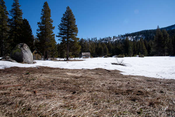
In addition to the manual surveys, DWR collects readings from 130 electronic snow sensors scattered throughout the state. Measurements indicate that statewide, the snowpack’s water equivalent is 11 inches, or 46 percent of the March average.
“The snowpack that we are measuring today is a critical element to all water resources managers in California, especially the State Water Project, which provides water to more than 27 million Californians and 750,000 acres of farmland,” said Molly White, chief of DWR’S State Water Project, Water Operations Office. “The data generated from snow surveys is one factor used to determine how much water will be allocated to the State Water Project Contractors.
The state’s largest six reservoirs currently hold between 92 percent (Oroville) and 132 percent (Melones) of their historical averages for this date. Lake Shasta, California’s largest surface reservoir, 107 percent of its historical average and sits at 78 percent of capacity.
DWR conducts five media-oriented snow surveys at Phillips Station each winter in January, February, March, April and, if necessary, May.
On average, the snowpack supplies about 30 percent of California’s water needs as it melts in the spring and early summer.
A patch of bare ground was visible at Phillips Station in the Sierra Nevada Mountains, the site of the California Department of Water Resources third snow survey of the 2020 season. The survey was held approximately 90 miles east of Sacramento off Highway 50 in El Dorado County. Photo taken on Thursday, February 27, 2020. Kelly M. Grow/California Department of Water Resources.
COBB, Calif. – A 3.5-magnitude earthquake just inside the Sonoma County border shook the Cobb and Kelseyville areas on Thursday afternoon.
The quake was reported at 3:27 p.m. Thursday near Bear Canyon in northern Sonoma County, according to the US Geological Survey.
The quake was centered Thursday afternoon early near Cobb 4.6 miles west-northwest of Cobb, 12.9 miles southwest of Clearlake and 15.8 miles north northeast of Healdsburg at a depth of 1.6 miles, the survey reported.
The survey reported receiving shake reports from Kelseyville and Middletown in Lake County, as well as from Mendocino, Napa, Sonoma, San Francisco and Santa Clara counties.
The US Geological Survey reported that a 3.7-magnitude quake occurred in Lake County, 3.5 miles west-northwest of Cobb, just after 10:34 a.m. Wednesday.
Email Elizabeth Larson at This email address is being protected from spambots. You need JavaScript enabled to view it.. Follow her on Twitter, @ERLarson, or Lake County News, @LakeCoNews.
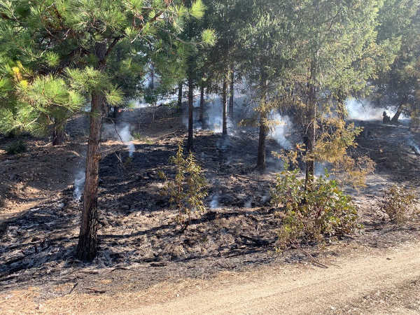
At the scene of the Baseball fire near Covelo in Northern California on Thursday, February 27, 2020. Photo courtesy of the Mendocino National Forest. NORTH COAST, Calif. – Containment on the Baseball fire on the Covelo Ranger District of the Mendocino National Forest reached 50 percent on Thursday evening.
The fire, which remains at 68 acres, is about 15 miles southeast of Covelo in Glenn and Mendocino counties.
About 100 personnel are working to complete containment of the fire. Assisting on the incident are engines and crews from the Mendocino, Klamath and Six Rivers national forests and from Oregon.
It has been determined that the Baseball fire started from previous pile burning on the Baseball prescribed fire project.
The fire is burning in grass, brush and timber in steep, rugged terrain. It is spreading at a low to moderate rate in a mosaic pattern, similar to the desired effects from a prescribed fire. There are no immediate threats to property or structures.
The U.S. Centers for Disease Control and Prevention has confirmed a possible first case of person-to-person transmission of novel coronavirus, or COVID-19, in California in the general public.
The individual is a resident of Solano County and is receiving medical care in Sacramento County.
The individual had no known exposure to the virus through travel or close contact with a known infected individual.
California has a strong health care system and public health infrastructure. The state has prepared for the potential spread of diseases, such as H1N1, in the past and is prepared and actively responding to the potential community spread of COVID-19.
Contact tracing in this case has already begun, officials said.
The health risk from novel coronavirus to the general public remains low at this time. While COVID-19 has a high transmission rate, it has a low mortality rate.
From the international data health officials have, of those who have tested positive for COVID-19, approximately 80 percent do not exhibit symptoms that would require hospitalization. There have been no confirmed deaths related to COVID-19 in the United States to date.
California health officials said they are carefully assessing the situation as it evolves.
“Keeping Californians safe and healthy is our number one priority,” said Dr. Sonia Angell, director of the California Department of Public Health and state Public Health officer. “This has been an evolving situation, which California has been monitoring and responding to since COVID-19 cases first emerged in China last year.”
Angell added, “This is a new virus, and while we are still learning about it, there is a lot we already know. We have been anticipating the potential for such a case in the U.S. and given our close familial, social and business relationships with China, it is not unexpected that the first case in the U.S. would be in California. That’s why California has been working closely with federal and local partners, including health care providers and hospitals, since the outbreak was first reported in China – and we are already responding.”
As in any public health emergency, the Department of Public Health's Emergency Operations Center has been actively coordinating response efforts across the state and preparing for possible community transmission. California continues to prepare and respond in coordination with federal and local partners.
This would be the first known instance of person-to-person transmission in the general public in the United States. Previously known instances of person-to-person transmission in the United States include one instance in Chicago, Illinois, and one in San Benito County, California.
Both cases were after close, prolonged interaction with a family member who returned from Wuhan, China and had tested positive for COVID-19, the disease caused by novel coronavirus.
As of Wednesday, including this case, California has had seven travel-related cases, one close contact case and now one community transmission.
As with any virus, especially during the flu season, health officials said there are a number of steps you can take to protect your health and those around you:
– Washing hands with soap and water. – Avoiding touching eyes, nose or mouth with unwashed hands. – Avoiding close contact with people who are sick are all ways to reduce the risk of infection with a number of different viruses. – Staying away from work, school or other people if you become sick with respiratory symptoms like fever and cough.
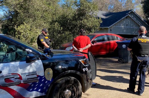
The Clearlake Police Department, California Department of Corrections and Rehabilitation Parole and Lake County Probation arrested seven individuals during a violent offender special enforcement operation on Tuesday, February 25, 2020, in Clearlake, California. Photo courtesy of the Clearlake Police Department. CLEARLAKE, Calif. – A multiagency special enforcement operation this week targeting violent offenders yielded seven arrests.
On Tuesday, the Clearlake Police Department, California Department of Corrections and Rehabilitation Parole, or CDCR, and Lake County Probation conducted a special enforcement operation across the city.
The operation included 24 specific locations of subjects known to be on active CDCR parole, post release community supervision – also known as PRCS – or probation, the Clearlake Police Department reported.
During the operation, seven subjects were arrested, including three felony and 4 misdemeanor arrests, police said.
At the locations where subjects were not arrested, police said compliance checks were conducted to confirm addresses and that the specific terms and conditions of the parole or probation status were being adhered to.
During the operation, three residences were found to have numerous code enforcement violations which made the structures unsafe to occupy. Those cases were later turned over to Clearlake Code Enforcement, according to the police report on the operation.
“These special enforcement operations supplement the day to day efforts of our personnel to make Clearlake a cleaner, safer city. A special thanks to CDCR Parole and Lake County Probation for their assistance,” the Clearlake Police Department said in a statement.

 How to resolve AdBlock issue?