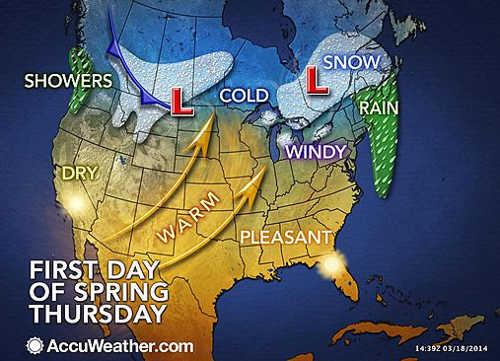
ACCUWEATHER GLOBAL WEATHER CENTER – AccuWeather.com reports the first day of spring will arrive unabated throughout the nation on Thursday, and milder weather will be in place for the start of the season for some.
Spring officially arrives on Thursday at 9:57 a.m. Pacific Daylight Time.
With the exception of the northern tier states, the Great Lakes and the interior Northeast, temperatures on Thursday will reach or exceed seasonable levels for March 20.
Highs are forecast to reach the 50s F in Boston, New York City, Washington, D.C., Cincinnati, Kansas City, Mo., and Portland Ore. Sixty-degree temperatures are in the offing from Richmond, Va., to Nashville, St. Louis, Denver, Salt Lake City and San Francisco.
However, chilly conditions with some snow will occur over northern New England, upstate New York and the Great Lakes, as well as the northern Rockies. Highs are projected to be in the 30s F from Caribou, Maine, to Buffalo, N.Y., and Minneapolis. Temperatures will peak in the 40s F in Detroit, Chicago, Fargo, N.D., Great Falls, Mont., and Seattle.
Temperatures are likely to climb from the central Plains to the Ohio Valley and Northeast late this week into the first part of the weekend. In many areas, temperatures may be 10 degrees higher Friday or Saturday compared to the day before.
As has been the case during much of the second half of the winter, cold air will fight back into next week.
According to AccuWeather.com Long Range Weather Expert Mark Paquette, “It is almost unthinkable, but it appears that a flow of air straight from the Arctic will develop again soon.”
A large area of high pressure is forecast to move southward from the North Pole and across the Canada Prairies.
“The cold outbreak looks to enter the North Central United States in two shots; one moves in this weekend, then a bigger blast will follow later next week,” Paquette said.
The arctic air is likely to penetrate as far south as the central Plains and the interior Southeast.
High temperatures could be held to the 20s F or lower over the northern tier states from parts of Montana to North Dakota, Minnesota, Michigan, upstate New York and northern New England. Temperatures may struggle to reach 32 F on one or more days from parts of the central Plains to the Midwest and Northeast.
In between the two pushes of cold air, there is the chance of some sort of snow event pushing eastward from the Central states to the Atlantic coast. Whether that event is a nuisance snowfall or a major snowstorm for some locations is uncertain at this time.
This winter has delivered well above-average snowfall for a number of locations from the North Central states to much of the East. Many cities are ranking in their top 10 snowiest winters ever.
Alex Sosnowski is an expert senior meteorologist for www.AccuWeather.com .