
 How to resolve AdBlock issue?
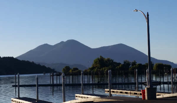
LAKE COUNTY, Calif. – An update to the U.S. Volcanic Threat Assessment puts the Clear Lake Volcanic Field among a group of volcanoes in the “high” risk category, with other volcanoes around California and the Pacific Rim rating even higher for danger.
The new U.S. Geological Survey report, which updates the first assessment released in 2005, ranks the 161 young, active volcanoes within the United State’s borders.
Sitting on the western shore of Clear Lake, the Clear Lake Volcanic Field’s most notable feature is Mount Konocti. It was ranked at No. 33, in the “high” threat category.
Elsewhere in California, the assessment lists Mt. Shasta and Lassen Volcanic Center in the “very high” ranking, placing them No. 5 and No. 11, respectively. The Long Valley Caldera in the Inyo National Forest near Yosemite National Park is in the very high threat category, at No. 18. The Mono-Inyo Craters, also near Yosemite, was listed in the “high” category at No. 24.
This 2018 update considers field and laboratory research that adds or removes volcanoes from the list of potentially active volcanoes, and updates the hazard and exposure factors used to produce a relative threat ranking of volcanoes.
Officials said the new document also adds or raises the threat level for 12 volcanoes and reduces or removes threat level status from 20 volcanoes.
The USGS said that, since 1980, there have been 120 eruptions and 52 episodes of notable volcanic unrest at 44 U.S. volcanoes.
John Ewert, a USGS volcanologist and lead author of the new assessment report based at the Cascades Volcanic Observatory in Vancouver, said the threat rankings are not an indication of which US volcano will erupt next but rather an indicator of the severity of impacts.
“The U.S. has quite a few geologically active volcanoes,” Ewert said.
Ewert said the 161 volcanoes in the study – eight less than the 2005 report, a net change due to the result of additions, naming changes and new research – make up about 10 percent of the earth’s active volcanoes, and have a large footprint over the United States extending from the Arctic to the tropics. Fourteen states and territories have volcanoes considered by this assessment.
“The US has nearly every type of volcano,” which are found in wildly different settings, said Ewert. What is known about their history varies greatly.
The survey systematically assesses U.S. volcanoes considered to be active or potentially active, and ranks the volcanoes based on 24 hazard and exposure factors. “To be included in the assessment, a volcano had to meet certain criteria,” said Ewert.
One of the key criteria is that a volcano has been active in geologically “recent time,” which Ewert explained is the Holocene, the current geological epoch which began nearly 12,000 years ago.
Once they assess the 24 factors for each volcano, they then group them into five categories. When ranking volcanoes, Ewert said that they combine the exposure and hazard scores, which highlight volcanoes that might otherwise have gotten lower.
He said 18 volcanoes in the United States are ranked as very high threat, and that group remains unchanged since the 2005 assessment.
There are 39 volcanoes in the high threat category, with Salton Buttes in California and Fourpeaked Mountain in Alaska added to the list; 49 volcanoes ranked as moderate, with new additions of Soda Lakes in Nevada and East Diamante in the commonwealth of the Northern Mariana Islands; 34 ranked as low threat; and 21 ranked as “very low threat,” the category that underwent the greatest changes due to new information, Ewert said.
This latest report also includes ash cloud risks, which was in the 2005 report. Ewert said the 2010 eruption in Iceland of the volcano Eyjafjallajökull, which went on for a six-month period and caused a six-day disruption in European air travel reported to be the most significant since World War II due to its enormous smoke output, is a good example of why it’s important to prioritize ash risk.
Ewert added that, when looking at the ash risk factor, you realize there are no geographically distant volcanoes.
The USGS said it uses the volcanic threat assessment to help guide and prioritize risk mitigation efforts at U.S. volcanoes through volcano research, hazard assessment, emergency planning and preparation and monitoring efforts with federal, state and local government partners.
Tom Murray is director of the USGS Volcano Science Center and line manager for the five volcano observatories in the United States – Alaska, California, Cascades, Hawaii and Yellowstone.
“It’s an important document for us,” he said of the report, which the USGS uses to guide and prioritize risk mitigation efforts, a cornerstone in the development of the National Volcano Early Warning System.
Research over the past decade has increased scientists’ understanding of volcanoes and also led to changes in the report, said Murray.
He acknowledged that there are monitoring deficiencies for most of the volcanoes, and that monitoring could be improved commensurate with their threat. “That’s the goal we’re trying to achieve.”
USGS officials also reported that many volcanoes are located in wilderness or national park areas, so they’re required to complete permits to establish monitoring sites, a process which can be slow. An example: The agency has been working for four years to get four monitoring sites placed around Glacier Peak in Washington.
As for other notable volcanoes, Margaret Mangan, scientist-in-charge at the California Volcano Observatory, said they closely monitor Mount Shasta, the hazard zone for which includes 9,500 square miles. She said 100,000 people live and work there on a regular basis, with large transient populations due to the presence of Interstate 5 and the National Forest.
There also is significant regional and state infrastructure in that area, including the Shasta Lake reservoir, which provides water to millions of people in the Bay Area and the Central Valley through the Bay Delta, Mangan said.
Mangan said there also is significant air traffic over Mount Shasta, with 800 jumbo jets flying over it on a daily basis.
“We have to think of the full gamut of life in volcanic areas,” Mangan said.
Mount Shasta is at No. 5, behind Kīlauea in Hawaii, Mount St. Helens and Mount Rainier in Washington, and Redoubt Volcano in Alaska.
USGS officials said Mount Rainier has 300,000 people in its downstream hazard zone.
Then there is the Yellowstone caldera in Wyoming, the location of the famed National Park.
“Yellowstone is an incredibly dynamic place. It’s always changing,” said Mike Poland, scientist-in-charge at the Yellowstone Volcano Observatory.
He said there is usually something going dormant or coming alive. “The ground is always moving up and down.”
The Yellowstone caldera experiences about 2,000 earthquakes a year. All of that activity, Poland added, is “what defines Yellowstone.”
In 2017 the USGS monitored the second largest seismic swarm in the Yellowstone caldera since monitoring began in 1970s. However, Poland added, “We don’t really have any indication that Yellowstone is doing anything abnormal.”
Ewert said scientists often get questions about the volcanoes in Alaska and Hawaii and whether eruptive events are connected to earthquakes and activity of other volcanoes. People like to make connections, he said, adding, “That’s what we do.”
However, unless volcanoes are right near each other, it’s difficult for them to share plumbing, Ewert said. “They tend to be independent operators.”
Understanding the Clear Lake Volcanic Field
Mangan said that the Clear Lake Volcanic Field is one of the centers that has a potential threat that only recently has been realized, which was why it was listed in the 2005 threat assessment as well as this newest document.
Mangan said field researchers work in the Clear Lake Volcanic Field, along with a special gas and water chemist, and field engineers who make sure the sensors already in the ground are maintained.
The field’s most prominent feature is the 300,000-year-old Mount Konocti, which Mangan said is believed to have last erupted about 11,000, right on the cusp of the Holocene era and on the borderline of what geologists would call “recent.”
“Mount Konocti is a series of several overlapping lava domes,” said Mangan. “It looks like one mountain but it’s actually made up of many eruptions in which very sticky, very viscous magma squeezed up through a vent and came out on the surface like globs of toothpaste.”
That magma mounded up around the vent to create a lava zone. “There have been several of those dome-forming eruptions,” Mangan said. “That is what created that mountain that is so majestic there on Clear Lake’s western shore.”
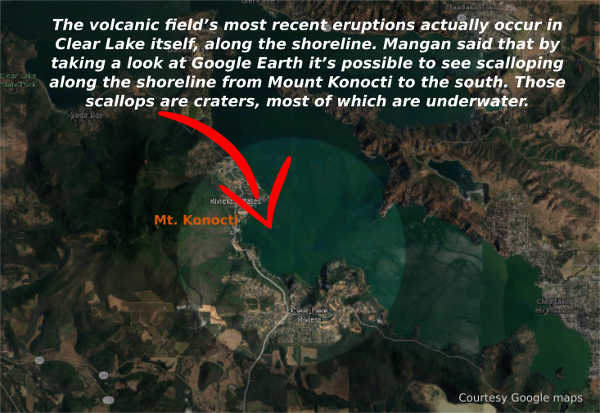
The volcanic field’s most recent eruptions about 11,000 years ago actually occurred in Clear Lake itself, along the shoreline. Mangan said that there were several of those “phreatic eruptions,” in which magma came up close to the surface of the earth and interacted with lake and groundwater, and produced steam explosions and rapid vaporization that created craters.
Mangan said that by taking a look at Google Earth it’s possible to see scalloping along the shoreline from Mount Konocti to the south. Those scallops are the craters, most of which are underwater, created by the phreatic eruptions.
In explaining the volcanic field, Mangan points out, “The Clear Lake Volcanic Field includes more than Mount Konocti.”
The other notables features that are of volcanic origin include areas where volcanic gases leaking out, which Mangan said is common.
Most of the magma that comes up to relatively shallow levels in the earth’s crust stays there. Mangan said it slowly cools and releases gas like what emerges at places like Sulphur Bank.
When a volcanologist talks of magma in the “near surface,” they mean 2 to 10 kilometers. For the Clear Lake Volcanic Field, Mangan said it’s around 6 kilometers.
There’s a pretty steady, low-level release of volcanic gases, most notably sulphur gases and carbon dioxide which originally was stored deep in the earth before being released from the magma and gradually making its way to the surface.
“It is a sign that the Clear Lake volcanic system isn’t done yet,” she said.
There also are areas on the lake like Soda Springs which people are warned to stay away from because of toxic gas emissions like carbon dioxide.
Mangan said carbon dioxide in water or snow can pond because it’s a dense gas. “You can build up some really big concentrations of C02, which is quite toxic to humans and other life forms.”
Since 2005, research and tracking of earthquakes, ground deformation and volcanic gas releases have shown that more research and monitoring are needed of the Clear Lake Volcanic Field, Mangan said. “It’s an important area of California.”
About two years ago, the California Volcanic Observatory started to shift some of its scientific research to the Clear Lake Volcanic Field, she said.
As a result, geophysical studies done in the past two years – in combination with work done in the 1970s and 1980s – shows that a zone of partially molten magma or rock exists under the field. As a result, they’re in the midst of additional research.
“We have a pretty robust research program going on in the Clear Lake area for the last two years,” she said. “We really need a better hazard zone map.”
They have a really good geologic map of the area which Mangan said can be used to create the volcano hazard zone map.
Mangan said they are working through the permitting process to add three more monitors in the Clear Lake Volcanic Field, which are expected to be in place in 2019 and 2020.
Before they can produce that hazard map and figure out where to put new monitoring equipment, they need to have a better understanding of what the current state of the volcanic system is, and where and how large are the zones of partially molten rock, Mangan said.
To do that, they’re using various types of geophysical measurements to provide a three-dimensional map of the subsurface of the Clear Lake Volcanic Field. One of the newest technologies for that purpose is magnetotellurics, which uses uses magnetism and electrical resistivity to map out zones where there are hot rock or partially molten rock below the surface.
The early results of the magnetotelluric survey are expected to come out sometime later this year, she said.
Another new technique they’re implementing is seismic tomography, which Mangan said uses seismometers to look at changes in seismic wave velocity.
When an earthquake happens and moves through the earth’s subsurface, those seismic waves will slow down in areas where there is partially molten or very hot rock. Mangan said that activity can be used to create surface images based on the seismic change velocity.
“We’re moving forward with the analysis of the current data that we’ve collected over the past two years, as well as adding new data to it. So it’s a work in progress,” she said, adding that it’s “one of the main ways to understand what’s underneath our feet up there.”
The USGS reported that its monitoring in the Clear Lake Volcanic Field and a collaborative effort with Calpine Corp. in The Geysers geothermal steam field provides real-time tracking of earthquake activity. In addition, the USGS periodically analyzes volcanic gases and hot springs in the region.
Mangan explained that The Geysers sits adjacent to the Clear Lake Volcanic Field on the western margin. “They are separate systems,” she said.
She added that what drives the geothermal system is hot rock and partially molten rock down deep in The Geysers region.
While people think about geothermal development and whether that production could impact a volcanic center, causing it to erupt, “It really is not the case,” said Mangan.
“The geothermal system is really shallow compared to the magmatic system,” she said, adding, “They’re just too far apart vertically.”
She said the Clear Lake Volcanic Field does have earthquakes, but they don’t happen often – only a few dozen a year – are usually below magnitude 2 and are deep, between 6 and 10 kilometers. That’s unlike the earthquakes in The Geysers, which are shallow and are the result of geothermal operations.
Increased monitoring planned
Mangan said volcano monitoring is essentially a three-legged stool, involving gathering data on earthquakes, ground deformation and gas emissions.
She said they have the seismicity and gas emissions covered pretty well, but don’t have ground deformation sensors in the field proper and want to increase overall monitoring. “We do need to increase our monitoring there.”
That’s why they plan to add three additional seismometers in 2019 or as late as 2020. It’s most important to have an adequate seismic network, which is the key type of sensor. “Right now it’s rather skeletal,” Mangan said of the monitoring system.
The California Volcanic Observatory has about 50 sensors, with four seismic sensors in the Clear Lake Volcanic Field, where Mangan said they want to fill in gaps, as it’s important to have a 360-degree arrangement in seismometers on a volcano.
Mangan said the new monitoring equipment already has been purchased. They just need to have their field engineers – who maintain the existing sensors – select the actual place on the ground to locate them.
Currently, monitoring equipment sends seismic data in real-time to the California Volcanic Observatory’s headquarters in Menlo Park. “That data is constantly streaming in,” Mangan said.
She said that if there’s anything unusual with respect to seismicity in the area, she’s attached to a beeper and she gets a notification.
At that point, she would interact with the observatory’s volcanologist to interpret that real-time monitoring.
Asked if that has happened for the Clear Lake Volcanic Field, Mangan said no, that so far nothing unusual has popped up.
Email Elizabeth Larson at
2018 Update to the U.S. Geological Survey National Volcanic Threat Assessment by LakeCoNews on Scribd